Media contact: Kristin Palm | kapalm@umich.edu | 313-593-5542
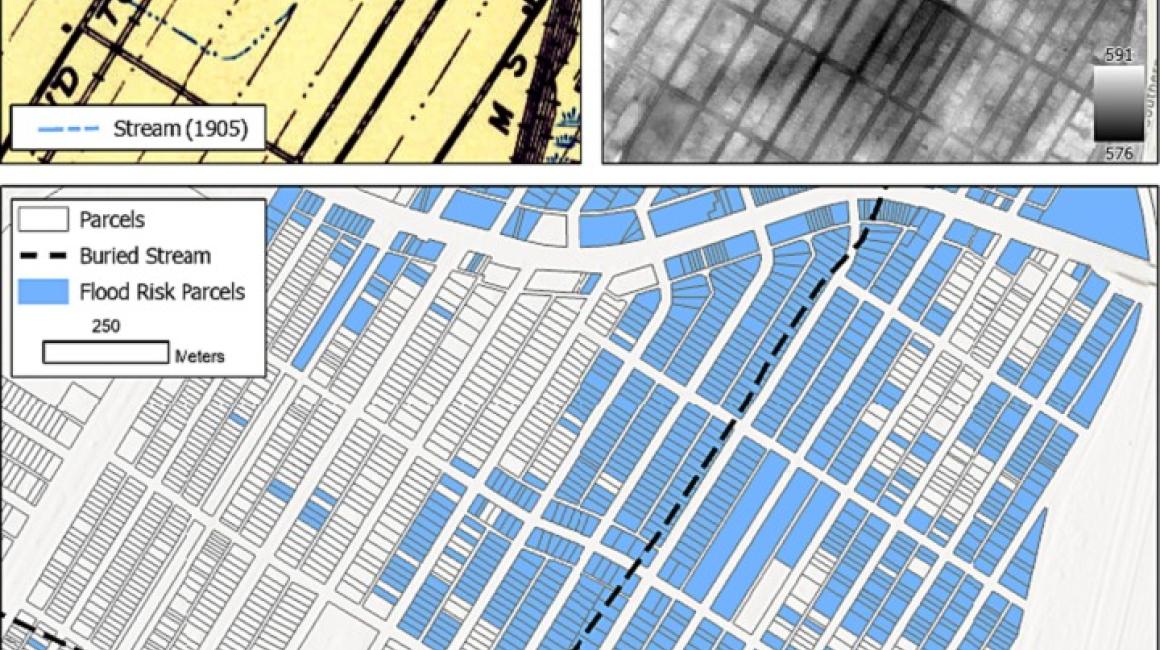
Heavy rains have become a regular concern in southeast Michigan, and projections indicate these rain events – and the flooding that follows – will only become more intense and frequent each year. Low-income neighborhoods in Detroit are hit especially hard by these storms. A new study by researchers at the University of Michigan-Dearborn details a little-examined flooding risk impacting these neighborhoods: ghost streams and wetlands. The research has implications for urban areas across the U.S.
Ghost streams and wetlands are waterways that previously existed but, as urban areas built up, were filled in to support new housing and other development. Detroit is estimated to have lost at least 85% of its urban streams since 1905.
The UM-Dearborn researchers used historical maps to identify these once-active waterways. They then correlated those waterways with flood risk data and historic Home Owners’ Loan Corporation maps that graded neighborhoods on perceived financial risk, a process known as redlining. Although redlining is now outlawed, its lasting effects on people of color, immigrants and residents of lower socioeconomic status – who were effectively barred from more affluent neighborhoods – have been pervasive. The team confirmed that flooding disproportionately impacts historically redlined neighborhoods, and that the buried waterways contribute to flooding risk.
“Across Detroit, historically redlined neighborhoods are interwoven with these ghost channels and wetlands,” explains Jacob Napieralski, professor of geology and GIS at UM-Dearborn and lead author of the study. “Although these waterways have been buried and built upon, they still flow during heavy rainstorms. They then flood basements, low-lying roads and large swaths of property, causing significant damage.”
Other effects of redlining compound the problems in these neighborhoods, the study found. In particular, once-redlined neighborhoods are often located near industrial sites, and contaminants from those sites can be washed in with the floodwaters.
“No matter if those industrial sites are active or relics, when it floods out, you have what is referred to as cumulative pollution,” Napieralski explains. “Of course, if you're close by, you're more likely to get hit with some really toxic waters.”
Redlined neighborhoods also have less vegetation and more impermeable surfaces. Vegetation, like trees and native grasses, can mitigate flooding, while concrete and exposed rooftops compound it. Residents in redlined neighborhoods are also less likely to have flood insurance.
“The communities that have wealth can afford insurance, they can afford rain gardens, they can manage coastlines,” Napieralski says. “Redlined neighborhoods are struck with the legacy of 70 to 80 years ago and the continued impacts on the quality of life.”
The study has implications far beyond Detroit. Napieralski says it’s critical for urban areas across the U.S. to identify their buried waterways in order to better protect vulnerable neighborhoods. Mitigation measures can include installing green infrastructure and informing residents on or near buried waterways of their increased flood risk.
“Cities should begin mapping their ‘hidden hydrology’ so that residents know they are at increased risk of flooding. Then, they can make informed decisions and prepare,” Napieralski says. “We need to step back and evaluate how we manage water in urban environments, and also think about the people and history and mitigating factors that we invest in one community and not the other. All these things add up and people who have the least bear the greatest burden.”
The study was conducted by Napieralski with graduate students Atreyi Guin and Catherine Sulich and published in the January 2024 issue of City and Environment Interactions.
Read the full paper
###


