
This article was originally published on July 12, 2021.
Normally when one of our stories mentions lidar — the laser-powered locating technology that’s similar to radar or sonar — we’re talking about autonomous vehicle navigation. But UM-Dearborn Assistant Professor Fred Feng, who studies non-motorized mobility safety issues, recently developed an application for lidar that could be a big help for those working in the active mobility space.
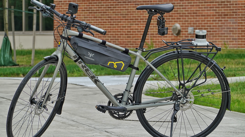
In the name of research, Feng has been strapping various sensors to bicycles and vehicles for years, and to date, that’s typically meant GPS and video cameras. They all work pretty well, especially if you’re looking to capture intimate observational data about bicycle riders’ real-world experiences. But Feng says this technology cocktail has a few important limitations. For example, if you want to take a detailed look at “overtaking” — a common high-risk scenario in which a driver passes a cyclist on the road — camera systems can’t really give you an accurate measurement of how close the car got to the cyclist. And even if you’ve equipped your bike with a proximity sensor, it can only record a single measurement at the moment the car temporarily draws even with the cyclist.
In contrast, Feng’s rear-rack mounted lidar system can give you a detailed 360-degree map of an entire overtaking event. “Using the lidar point cloud data, we can actually see the vehicle approach from behind, pass the cyclist, and then continue on down the road, and we have accurate distance measurements all throughout this process,” Feng says. Not only that, but the lidar data can be used to observe many other details — like the speed and maneuvers of the vehicle, and other objects in the environment. Check out this visualization to see it in action.
Feng says this much more comprehensive view of driver-cyclist interactions could have multiple applications. Road engineers could use the technology to study problematic areas of roadways and create safer road designs for all users. Product designers might use the data to come up with new safety devices. And Feng’s fellow researchers could use the point cloud data to study their own road safety interests. In fact, Feng’s team plans to make some of their point cloud data public to encourage just that. Incidentally, that’s a lot easier to do with lidar-based systems, since unlike a camera system, the data isn’t laden with many common privacy issues — like facial features of passersby who didn’t sign-up to be in the research data.
In fact, though Feng doesn’t have immediate plans to do so, future advances in lidar technology could allow him to study safety issues impacting another key road user: pedestrians. Just a few years ago, he says lidar systems were still too big and expensive to mount to bikes. But with all the recent innovations in lidar-sensing technologies, his bike-mounted system suddenly became possible. Give it a few years, and a lidar system you can velcro to your arm might give researchers like Feng an even more complete suite of tools to design safer streets for everyone.
###
Interested in talking with Assistant Professor Fred Feng about this topic? Members of the media can drop us a line at [email protected] and we’ll put you in touch. You can also find out more about Feng's work at his research group's website.


